WASHINGTON, D.C. (February 9, 2021)—-
Good Morning!
Congratulatory Message on the 30th Anniversary of the Visegrad Group (V4)
Department of State
The United States congratulates the Czech Republic, Hungary, Poland, and Slovakia on 30 years of partnership in the Visegrád Group (V4) format. As NATO Allies and EU member states, V4 countries play important roles in strengthening Central Europe and the Transatlantic Alliance. Since its establishment in 1991 to support accession to NATO and the European Union, the V4 has amplified the collective voices of the Czech Republic, Hungary, Poland, and Slovakia on important regional issues, including by supporting the Euro-Atlantic integration of the Western Balkans and the EU’s Eastern Partnership countries through International Visegrád Fund programs to strengthen democratic institutions and civil society. The United States looks forward to continued dialogue with the Visegrád Group to address shared challenges, including fighting and recovering from the global pandemic; improving cyber and energy security; combating climate change; countering disinformation and malign influence; and strengthening democratic institutions, the rule of law, and independent media.
Sports Heroes Who Served: Baseball Great Jackie Robinson Was WWII Soldier
Department of Defense: By David Vergun
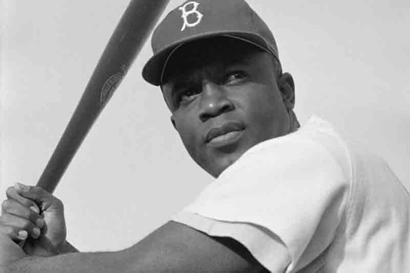
Jack Roosevelt Robinson — better known as Jackie Robinson — was born in Cairo, Georgia, on Jan. 31, 1919, the same month former President Theodore Roosevelt died. That’s how he got his middle name.
In 1920, his father, a sharecropper, left the family. Robinson’s mother and her six children moved to Pasadena, California, where she worked at a variety of jobs to support the family. But they lived in poverty.
In high school, Robinson played several sports at the varsity level and lettered in four of them: football, basketball, track and baseball.
In 1936, Robinson won the junior boys singles championship in the annual Pacific Coast Negro Tennis Tournament and he also earned a spot on the Pomona, California, annual baseball tournament’s all-star team, which included future Hall of Famers Ted Williams and Bob Lemon.
After graduating from Pasadena Junior College in 1939, he enrolled at the University of California at Los Angeles, where he became the first UCLA athlete to win varsity letters in four sports: baseball, football, track and basketball.
During World War II in 1942, Robinson was drafted and assigned to a segregated Army cavalry unit in Fort Riley, Kansas. In January 1943, Robinson was commissioned a second lieutenant.
Robinson was then assigned to Fort Hood, Texas, where he joined the 761st “Black Panthers” tank battalion.
On July 6, 1944, Robinson boarded an Army bus. The driver ordered Robinson to move to the back of the bus, but Robinson refused. The driver called the military police, who took Robinson into custody. He was subsequently court martialed, but he was acquitted.
After his acquittal, he was transferred to Camp Breckinridge, Kentucky, where he served as a coach for Army athletics until receiving an honorable discharge in November 1944.
In 1945, Robinson began playing baseball for Missouri’s Kansas City Monarchs, one of the teams in the Negro leagues. About that time, Branch Rickey, club president and general manager of the Brooklyn Dodgers, began to scout the Negro leagues for talent. Rickey selected Robinson from a list of promising Black players and interviewed him for a possible assignment on Brooklyn’s International League farm club, the Montreal Royals.
During the interview, Rickey told Robinson that he’d have to be willing to withstand the inevitable racial abuse that would be directed at him because there were no Black players in Major League Baseball.
Soon after Robinson was onboard with the Dodgers, Rickey signed another Black baseball player, Johnny Wright, who happened to be a Navy veteran of World War II.
On April 15, 1947, the Dodgers called Robinson up to the major leagues where he played first baseman.
Robinson did experience a lot of hatred from fans and other baseball players who felt that Black players should not be allowed in Major League Baseball.
As a Brooklyn Dodger, Robinson was:
- A six-time All-Star from 1949 to 1954.
- A 1955 World Series champion.
- MLB Rookie of the Year in 1947.
Some other interesting facts about the baseball legend include:
- In 1950, Robinson played himself in the movie “The Jackie Robinson Story.”
- On June 4, 1972, the Dodgers retired Robinson’s uniform number, 42.
- On April 15, 1997, No. 42 was retired from all of MLB; Robinson is the only player to receive this honor.
- From 1957 to 1964, Robinson was the vice president for personnel at Chock full o’ Nuts, a coffee brand, making him the first Black person to serve as a vice president of a major U.S. corporation.
Until Robinson broke the color barrier in 1947, few Black players made it into baseball history. The first African-American baseball player in MLB was William Edward White, who played for the Providence Grays in 1879 in Providence, Rhode Island. Five years later, Moses Fleetwood Walker and his brother, Weldy Walker, played for the Toledo, Ohio, Blue Stockings.
Related Story: Sports Heroes Who Served: WWI Soldier Helped Desegregate Baseball
New Timeline of Deadliest California Wildfire Could Guide Lifesaving Research and Action
On a brisk November morning in 2018, a fire sparked in a remote stretch of canyon in Butte County, California, a region nestled against the western slopes of the Sierra Nevada mountains. Fueled by a sea of tinder created by drought, and propelled by powerful gusts, the flames grew and traveled rapidly. In less than 24 hours, the fire had swept through the town of Paradise and other communities, leaving a charred ruin in its wake.
The Camp Fire was the costliest disaster worldwide in 2018 and, having caused 85 deaths and destroyed more than 18,000 buildings, it became both the deadliest and most destructive wildfire in California’s history, two records the fire still holds today.
What made the Camp Fire so devastating? And what lessons can we learn to prevent another disaster of this scale? Researchers at the National Institute of Standards and Technology (NIST) have begun to answer these questions by investigating the conditions leading up to the fire and meticulously reconstructing the sequence of events describing the first 24 hours of its progression. A new report containing the timeline identifies areas where more research is needed to improve life safety and reduce structural losses. It also offers a detailed look at how a large and deadly fire advances — information that will become increasingly valuable as fire seasons continue to intensify.
“The information we collected on the timeline is extremely powerful by itself, not only for Paradise but for other similar communities, to help them understand what they may encounter and better prepare, whether it is at a community or at the first responder level,” said NIST fire protection engineer Alexander Maranghides, who led the timeline reconstruction.
To piece together the puzzle of the Camp Fire, the team carried out discussions with 157 first responders, local officials and utilities personnel who were present during the fire. The team documented sightings of fire or smoke and efforts to fight the fire or evacuate, as well as insights into community preparedness and weather conditions.
The researchers sought to back up observations made during the fire with additional data sources before adding new puzzle pieces to the timeline. With the help of the California Department of Forestry and Fire Protection (CAL FIRE), Paradise Police Department and others, the team gained access to and reviewed large data sets, including radio logs, 911 calls, dashboard and body camera recordings, and drone and satellite images. They also looked to images in social and news media to corroborate the sightings of discussion participants.
By the end of the painstaking process, the authors of the report incorporated more than 2,200 observations into the timeline, which is broken up into 15 separate segments to capture concurrent events throughout different sections of Butte County.
A Landscape Ripe for Disaster
The team’s investigation revealed several conditions throughout Butte County that, taken together, created favorable conditions for an inferno. On the day the fire broke out, wind gusts were powerful, blowing up to about 48 kilometers (30 miles) per hour, and were almost exclusively pointed southwest, toward Paradise and the smaller communities of Magalia and Concow. The 200 days of drought preceding the fire had also transformed much of the region’s lush terrain into combustible ground.
And perhaps counterintuitively, Maranghides said, the relatively large distance between the fire’s origin and the edge of Paradise (about 11 kilometers, or 7 miles) contributed to the massive, 3.2-kilometer (2-mile)-long fire front that crashed into the town.
“If a fire starts far away, upwind, then it has time to develop and expand. By the time it hits the community it is so large and so powerful that it could wipe everything out,” Maranghides said. “But if it ignites closer, the fire can be so much smaller. It takes a much smaller bite out of the community, and people may have a fighting chance.”
The report indicates that town officials in Butte County went to great lengths to prepare for fires, having cleared vegetative fuels near critical infrastructure and bolstered emergency communications in the weeks and months prior. However, dense vegetation had still accumulated throughout Paradise — a factor enhanced by the nearly 100 years the town had gone without experiencing a wildfire.
The researchers learned that, although Paradise made resources available for residents to remove trees, many did not take the city up on its offer. One participant in the reconstruction noted that residents were often attracted to the lifestyle of “living in the forest” provided by the town.
With a gamut of unfavorable conditions at play, a spark in the wilderness quickly became a raging inferno.
Breaking Down the Camp Fire’s Assault
The fire’s siege on Paradise, which ultimately destroyed 85% of the town’s buildings, began before its front line reached the city limits. Showers of burning debris were carried by the wind ahead of the main fire into town, where the embers ignited buildings and vegetation, riddling the town with dozens of smaller fires that ate up precious firefighting resources.
Propelling the Camp Fire’s structure-destroying spree were fires that spread within and between plots of land, or parcels, rather than from the fire front. Sources such as burning sheds, plants, vehicles and neighboring houses caused many buildings to catch fire, either through direct contact with flames or embers generated in parcels.
Paradise’s defenses quickly fell once the fire front reached town. The incident commander leading the emergency response recognized the fire’s speed and intensity and ordered his personnel to abandon all firefighting efforts just 45 minutes after the fire arrived. “Save lives, keep evacuation moving,” the incident commander said over the radio.
Although the focus of emergency response narrowed on saving lives, evacuation efforts were stifled by burnovers — life-threatening events in which residents or first responders are overrun by flames, cutting them off from escape routes. Across Paradise and Concow there were 19 burnovers at least, some of which involved downed power lines or flaming vegetation that blocked off roads, causing gridlock and putting lives in danger.
In the past, recorded burnovers were sparse, with reports attributing few or none to most fires. Hardly any have been scrutinized as heavily as the Camp Fire, however, which could partially explain the event’s high number of documented burnovers. Another critical contributor was likely Paradise’s heavily wooded nature, Maranghides said.
The abundance of burnovers during the Camp Fire may not be an isolated event, but part of a larger trend, particularly for communities where vegetative fuels have built up over many years.
“The significant activity we’ve experienced in the last few years may indicate that burnovers are becoming more frequent than they used to be,” said CAL FIRE chief Steven Hawks, a co-author of the report. “My sense is that because fires are burning so fast now, there is more potential for people to become trapped.”
Toward Fire-Safe Communities
US Department of Commerce: Jonathan Griffin
With this report, NIST has shone light on the many aspects of the Camp Fire’s multipronged attack. Research into these threats could fill critical knowledge gaps, paving the way for science-based codes, standards and practices that could help communities outsmart fires.
What’s urgently needed, the authors write, are methods of capturing the severity of burnovers and a better understanding of how they occur in the first place. Studies in this area could make way for guidelines on reducing their likelihood and protecting evacuation routes.
As for buildings, there are already two known options for increasing their chances of surviving a wildfire. The first is to make sure combustible items within a parcel (plants, sheds, etc.) are not too close to a structure, and the second is to increase the fire resistance of a structure’s materials. But striking a cost-effective balance between the two is difficult with the limited information on how various fuel sources threaten buildings.
“We need to improve our understanding at the parcel level because it’s the parcel-level exposures that drive the building’s survivability,” Maranghides said. “You cannot just look at the building in absence of what’s around it.”
Once researchers can put numbers to the behavior of embers and combustibles in parcels, it may become more clear what a particular building needs in terms of spacing and hardening to hold up to a wildfire.
City officials could use the report’s timeline for emergency planning as well. By having a detailed description of events such as burnovers in front of them, members of city councils or public works departments in wildfire-prone regions could evaluate their own emergency plans and potentially identify vulnerabilities.
There is currently no standard method of comparing the wildfire hazards of communities. So, although the researchers could draw individual similarities between Paradise and other communities in Northern California, they were unsure how the town compared as a whole. The team aimed to bridge this gap by developing a framework in the form of a document encouraging city officials to record specific information on fuels, population, emergency notifications and other aspects of the community.
If adopted and employed statewide in California and in other wildfire-prone areas, the framework, which appears in the report, could reveal areas most at risk and worthy of attention and resources, Maranghides said.
In the hands of first responders, the new report could become valuable training material. Using data on how quickly and intensely the fire grew, commanders could build tabletop exercises to practice deploying firefighting resources to counter its spread and save lives.
An event on the scale of the Camp Fire makes it clear that action is needed at all levels to protect communities from wildfires, Hawks said. And that need is perhaps more urgent now than ever.
“Going forward, there’s no reason to believe that fire activity and severity is going to lessen anytime soon,” Hawks said. “We’re never going to get rid of wildfires, natural or human-caused. But we can learn how to live with and work together to mitigate them.”
The full report is now available, along with several maps portraying the fire spread. The timeline of fire progression will form the basis for subsequent reports on evacuation and emergency response during the Camp Fire that the NIST team plans to publish in the coming months.
")
NOAA Satellites Helped Save a Record 421 Lives in 2019
National Oceanic and Atmospheric Administration: John Leslie
The same NOAA satellites that helped forecasters track weather and wildfires were also critical in rescuing a record 421 people from potentially life-threatening situations throughout the United States and its surrounding waters in 2019.
NOAA’s polar-orbiting and geostationary satellites are part of the global Search and Rescue Satellite Aided Tracking System, or COSPAS-SARSAToffsite link, which uses a network of U.S. and international spacecraft to detect and locate distress signals from emergency beacons aboard aircraft, boats and from handheld Personal Locator Beacons (PLBs) anywhere in the world.
Of the 421 U.S. rescues last year, 306 were water rescues, 38 were from aviation incidents and 77 were from events on land, where PLBs were used. Florida had the most SARSAT rescues with more than 100, followed by Alaska with more than 50. The previous rescue record of 353 (total) was set in 2007.
When a NOAA satellite pinpoints the location of a distress signal in the U.S., the information is relayed to the SARSAT Mission Control Center at NOAA’s Satellite Operations Facility in Suitland, Maryland. From there, the information is sent quickly to Rescue Coordination Centers, operated either by the U.S. Air Force for land rescues, or the U.S. Coast Guard for water rescues. NOAA also supports rescues globally by relaying distress signal information to international SARSAT partners.
“Each person rescued underscores the success of nearly 40 years of teamwork with the U.S. Coast Guard, the U.S. Air Force, NASA and our international partners,” said Steve Volz, Ph.D., assistant NOAA administrator for its Satellite and Information Service.
In one harrowing case last year, the impact of the crash of a small aircraft near Skwentna, Alaska, activated the emergency beacon onboard. The Alaska Rescue Coordination Center relayed the distress location to the Alaska Air National Guard responders, who pulled the two passengers from the wreckage and they received medical treatment at an area hospital.
In another rescue, six people were saved from a sinking boat 20 miles east of Sunny Isles, Florida. The U.S. Coast Guard received the emergency beacon alert and directed an emergency response boat to the scene.
Since its start in 1982, COSPAS-SARSAT has been credited with supporting more than 48,000 rescues worldwide, including nearly more than 9,000 in the United States and its surrounding waters.
By law, beacon owners are required to register their devices online with NOAA. The registration information helps provide better and faster assistance to people in distress, and can guard against false alarms. It may also provide information about the location of the emergency and what type of help may be needed.
Find out more about NOAA SARSAT.
U.S. Census Bureau Releases Key Statistics on Nation’s African American Population in Honor of Black History Month
US Census Bureau

The following is a cross-post from the U.S. Census Bureau
To commemorate and celebrate the contributions to our nation made by people of African descent, American historian Carter G. Woodson established Black History Week (then called “Negro History Week”) nearly a century ago. The event was first celebrated during the second week of February 1926, selected because it coincides with the birthdays of both Abraham Lincoln (February 12) and abolitionist/writer Frederick Douglass (February 14). That week would continue to be set aside for the event until 1976 when, as part of the nation’s bicentennial, it was expanded to a month. Since then, U.S. presidents have proclaimed February as National African American History Month.
The following facts are made possible by the invaluable responses to the U.S. Census Bureau’s surveys. We appreciate the public’s cooperation as we continuously measure America’s people, places and economy.
48.2 million
The Black population, either alone or in combination with one or more races, in the United States in 2019.
30.7%
The percentage of the employed Black population age 16 and older working in management, business, science and arts occupations in 2019.
124,004
The number of Black-owned employer businesses in the United States in 2017.
2.1 million
The number of Black military veterans in the United States nationwide in 2019.
Voting Rates
- Voting rates in the 2018 congressional election.
- Voting rates in the 2016 presidential election.
- Voting rates in the 2014 congressional election.
Income, Poverty and Health Insurance
More Stats
See a detailed profile on the Black population from the 2019 American Community Survey. Statistics include:
- Families and children.
- Marital status.
- Grandparents living with grandchildren.
- Jobs.
- Labor force participation.
- Occupation.
- Commuting.
- Housing.
For more information, see the U.S. Census Bureau’s latest Facts for Features National African American (Black) History Month: February 2021